Isaias warnings are over and the city lists no road closures. Trash pickup ran late as crews cleared debris, and the Downtown Marina boat ramp has reopened.
Every tropical storm and hurricane warning for Panama City is over. Water in St. Andrews Bay and East Bay has dropped back below flood stage. The beaches are still dangerous through Sunday, and some roads and the downtown marina remain closed.
Updated Oct. 22: the Downtown Marina boat ramp is open again after repairs to its stairs and dock, according to the city’s Alert Center notice.
Updated Oct. 15: the city’s recovery page no longer lists any road closures, the Tarpon Dock drawbridge is working again, and trash pickup is running late while crews clear storm debris. See our debris and trash pickup story. The Downtown Marina boat ramp is still closed.
Updated Oct. 10, 10:45 a.m. CDT: warnings canceled, bay gauges back below flood stage, the U.S. 231 closure no longer listed, and the marina boat ramp closed for dock damage.
The National Weather Service in Tallahassee dropped all watches and warnings for the area in its local statement at 4:09 a.m. CDT Saturday. It said Isaias had “pulled far enough away from the region” to end them.
At 10 a.m., Isaias was a post-tropical cyclone about 50 miles south of Birmingham, Alabama. Its top winds were near 35 mph, according to the 10 a.m. advisory, now written by the Weather Prediction Center.
How the storm hit
Isaias made landfall near Destin, about 50 miles west of Panama City, at about 8:30 p.m. CDT Friday. It came ashore with sustained winds of about 105 mph, according to the National Hurricane Center’s 10 p.m. discussion.
A National Ocean Service station in Panama City Beach recorded a gust of 83 mph and a sustained wind of 72 mph. The hurricane center reported both readings in its 9 p.m. update.
The weather service said the heaviest rain fell west of Bay County. Radar estimated 7 to 8 inches from coastal Walton County into Geneva and Coffee counties in Alabama.
What the weather service still warns about
The weather service said Saturday that the danger is now what the storm left behind. Its statement asked people to:
- watch for downed trees, downed power lines and standing water
- stay out of evacuated areas until local officials have checked roads and bridges
- stay away from damaged neighborhoods instead of sightseeing, so crews can work
- use flashlights, not candles, when checking damage, and wear protective gear with chainsaws
The Storm Surge Warning was replaced by a Coastal Flood Advisory for minor flooding in coastal Bay County until 11 a.m. CDT Saturday. The weather service said remaining showers, and a small chance of tornadoes, would focus east of Bay County, along the Forgotten Coast and the Big Bend.
The Panama City forecast is mostly sunny Saturday with a high near 79 degrees, and sunny Sunday with a high near 81, according to the NWS forecast for Panama City.
Stay out of the Gulf through Sunday
The weather service has a High Surf Warning for Walton and Bay County beaches until 10 a.m. CDT Sunday. It now expects breaking waves of 2 to 14 feet in the surf zone and “significant beach erosion.” A high rip current risk runs through late Sunday night.
“Everyone should remain out of the water due to life-threatening surf conditions,” the warning said. It also told people to stay off jetties, piers and other waterside structures.
Water in the bay is back down
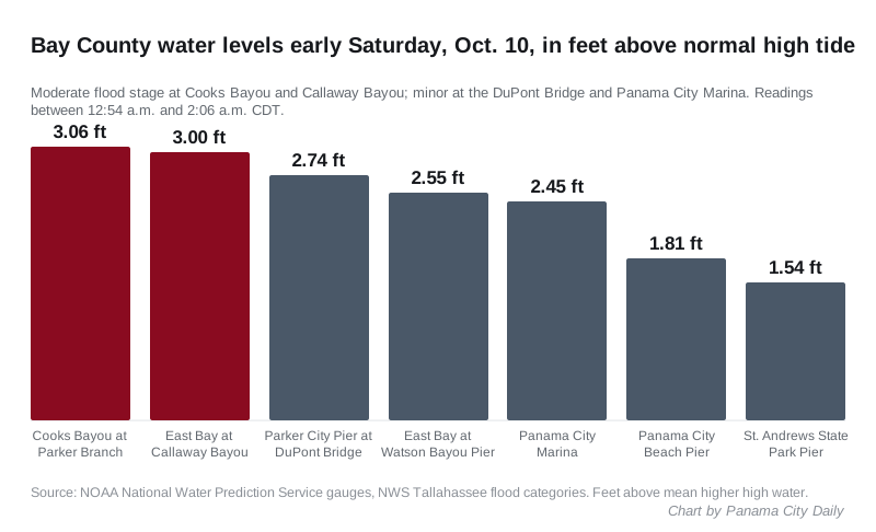
Every Bay County tide gauge was below flood stage by late Saturday morning, according to the NOAA National Water Prediction Service. Overnight, two of them had reached moderate flooding. The readings, in feet above the normal high tide, were:
| Gauge | Early Saturday | Late Saturday morning |
|---|---|---|
| Cooks Bayou at Parker Branch | 3.06 feet (moderate flooding) | 0.9 feet (no flooding) |
| East Bay at Callaway Bayou | 3 feet (moderate flooding) | 0.9 feet (no flooding) |
| Parker City Pier at DuPont Bridge | 2.74 feet (minor flooding) | 0.8 feet (no flooding) |
| East Bay at Watson Bayou Pier | 2.55 feet (action stage) | 0.72 feet (no flooding) |
| Panama City Marina | 2.45 feet (minor flooding) | 0.68 feet (no flooding) |
| Panama City Beach Pier | 1.81 feet (action stage) | 0.53 feet (no flooding) |
| St. Andrews State Park Pier | 1.54 feet (action stage) | -0.02 feet (no flooding) |
The early readings were taken between 12:54 a.m. and 2:06 a.m. CDT. The later ones were taken between 8:36 a.m. and 10 a.m. CDT. Each gauge has its own flood thresholds, set by the weather service. Parker and Callaway sit on East Bay, east of Panama City; Callaway is about eight miles away.
Inland, Bear Creek at U.S. 231 is still rising slowly. It read 20.88 feet at 9 a.m., up from 20.5 feet at 1 a.m. That is above the 19-foot action stage but below the 23-foot level where the weather service counts minor flooding.
Roads and the marina
The City of Panama City’s Isaias update page, updated Saturday, lists these closures:
- U.S. 98 westbound, from Mound Avenue to High Avenue, because light poles are leaning toward the road. The city asked drivers to find another route.
- The Downtown Marina entrance, because of high water on the marina’s T-Dock.
- The boat ramp at the Downtown Panama City Marina, closed until further notice because both docks were damaged in the storm. The T-Dock is also closed, and the city asked people to avoid the area.
Friday night’s list also had U.S. 98 closed in both directions between Michigan Avenue and the Hathaway Bridge flyover. That closure is not on the city’s Saturday list. The city has not said in its update when it reopened.
The Florida Department of Transportation’s FL511 closures list showed no Bay County closures at about 10:30 a.m. CDT Saturday. On Friday it had listed U.S. 231 closed both ways near County Road 2312 (Baldwin Road) for flooding. Closures for fallen trees were still listed in Okaloosa, Santa Rosa and Escambia counties to the west.
Treat any intersection with a dark traffic signal as a four-way stop. Our road construction and closures page links the FL511 map and FDOT’s District 3 updates.
Since the weekend
The city’s recovery update was last updated Tuesday, Oct. 13. It no longer lists the westbound U.S. 98 closure between Mound Avenue and High Avenue, or the downtown marina entrance. It does not say when they reopened.
- The Tarpon Dock drawbridge on East Beach Drive, between The Cove and downtown, has power again. The city said it can lift for boats and is open to cars.
- The marina boat ramp is still closed. In an Oct. 13 notice, the city said it has put heavy-duty concrete barricades at the ramp. Anyone who moved the earlier barricades to launch a boat must get it back out at another ramp.
- Trash pickup was due to resume Monday, Oct. 12, and is running late. The city estimated that about 38 trees came down across Panama City, and said nearly every household has storm debris to collect.
Recovery and damage reports
The city said its crews are patrolling streets, inspecting storm drains and clearing debris.
If your home or business was damaged, the city asks you to fill in Bay County’s damage assessment form. The city said the form does not request disaster money or file an insurance claim. It said the reports help officials ask for the recovery supplies the community needs.
From the city’s Oct. 10 update page:
- City Hall and non-essential city operations were closed until Monday morning, Oct. 12.
- All Parks, Culture and Recreation rentals, programs and games for Friday and Saturday were canceled.
- The MLK Jr. Recreation Center is scheduled to reopen at noon Sunday, Oct. 11, if the weather and the building allow.
- For shelter questions, the city lists the Citizens Information Center at 850-248-6090.
The city declared a local state of emergency at about 2 p.m. Wednesday, Oct. 7. It said the declaration lets it seek state and federal help and reimbursement for its storm costs. City crews handed out more than 8,000 sandbags before distribution ended at noon Friday.
Weather radio is back
The Panama City NOAA Weather Radio transmitter, KGG-67 on 162.550 MHz, went off the air Friday evening. The weather service said at 5:33 a.m. CDT Saturday that it was back on the air. The city also points people to AlertBay to sign up for emergency alerts by phone.
What it means for you
- Watch for hazards on the roads. Never drive through standing water or around barricades. Check FL511 or dial 511 before you set out.
- Stay out of the Gulf until the High Surf Warning ends at 10 a.m. Sunday. The rip current risk lasts through Sunday night.
- Do not launch from the downtown marina. The boat ramp is closed until further notice.
- Report damage to your home or business on Bay County’s damage assessment form.
- Run generators outside, at least 20 feet from doors, windows and vents. The Panama City Fire Department said never to use grills, camp stoves or heaters indoors because of carbon monoxide.
- Keep away from downed lines. Our power outages page lists who to call for each utility in Panama City.
- Report a blocked storm drain to the city at 850-872-3112. For emergencies, call 911.
We could not confirm any figures for power outages, damage or injuries in Panama City from official sources by Oct. 15. We will update this page if the city or the county publishes them. For storm planning, see our hurricane preparation guide.
Frequently asked questions
Is Panama City still under a hurricane or tropical storm warning?
No. The National Weather Service in Tallahassee said early Saturday, Oct. 10, that all watches and warnings for the area had been canceled. A High Surf Warning for Bay County beaches lasts until 10 a.m. CDT Sunday.
Which roads are closed in Panama City after Isaias?
None from the storm. The city’s recovery update, last updated Oct. 13, no longer lists the westbound U.S. 98 closure between Mound Avenue and High Avenue. Michigan Avenue is closed between West 20th Court and West 22nd Street until about Dec. 18 for planned road work. Check FL511 before driving.
When can I go back in the water at Panama City Beach?
Not before Monday. The National Weather Service has a High Surf Warning for Bay County beaches until 10 a.m. CDT Sunday, with breaking waves of 2 to 14 feet, and a high rip current risk through late Sunday night.
Is the Panama City Marina boat ramp open?
Yes. The city said the boat ramp at the Downtown Marina is back open after repairs to the stairs and dock.
How do I report storm damage to my home?
Fill in Bay County’s damage assessment form. The city said it does not request disaster money or file an insurance claim, but it helps officials ask for the recovery supplies the community needs.
Have your say